
INFRASTRUCTURE SURVEYS
The importance of accurate data for infrastructure is critical.
We provide an effective and timely solution for your project requirements that you can have confidence in.
Our laser scanning experience will set a project off in the right direction with precision 3D modelling of a built environment.
Our collaboration with multiple underground utility locaters also equips us with a highly mobile and competent team.
We provide the design team with an industry standard compliant BIM-ready model, which assists in understanding the relationship and connectivity between below and above ground services & surrounding infrastructure.
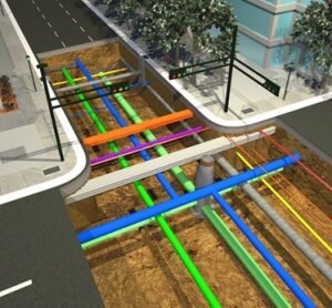
Underground Utility Mapping
Structural plant BIM
Precision setout
Work –as-executed surveys
BIM Underground Services